Monday, July 25, 2011
The Final Battle
Bin Laden had not been heard from in almost three years. Posted just before election day, the video was clearly directed at an American audience that was facing a decision - continue with the status quo, or reverse course with new leadership. The CIA had just reported that Saddam Hussein did not have weapons of mass destruction, placing in doubt the credibility of President Bush's decision to invade Iraq. The number of U.S. casualties had topped 1,000, the Abu Ghraib atrocities were front-page news, and a new government in Iraq gave a glimmer of hope that American forces should and would be coming home soon.
Bin Laden's missive gave Americans even more to consider. "We are continuing this policy in bleeding America to the point of bankruptcy. Allah willing, and nothing is too great for Allah," bin Laden said. He said his fighters did the same thing to the Soviet Union in Afghanistan in the 1980s, "using guerrilla warfare and the war of attrition to fight tyrannical superpowers."
"We, alongside the mujahideen, bled Russia for 10 years until it went bankrupt and was forced to withdraw in defeat," bin Laden said.
He also said al Qaeda has found it "easy for us to provoke and bait this administration."
"All that we have to do is to send two mujahedeen to the furthest point east to raise a piece of cloth on which is written al Qaeda, in order to make generals race there to cause America to suffer human, economic and political losses without their achieving anything of note other than some benefits for their private corporations," bin Laden said.
As part of the "bleed-until-bankruptcy plan," bin Laden cited a British estimate that it cost al Qaeda about $500,000 to carry out the attacks of September 11, 2001, an amount that he said paled in comparison with the costs incurred by the United States.
"Every dollar of al Qaeda defeated a million dollars, by the permission of Allah, besides the loss of a huge number of jobs," he said. "As for the economic deficit, it has reached record astronomical numbers estimated to total more than a trillion dollars.
"It all shows that the real loser is you," bin Laden said. "It is the American people and their economy.""It all shows that the real loser is you," bin Laden said. "It is the American people and their economy."
The total U.S. national debt, now over $14 trillion, was more than $7 trillion in 2004. The U.S. federal deficit in 2010 was almost four times as much as it was in 2004. Our unemployment rate rose from 5.4% in October 2004 to 9.2% today.
Now, Osama bin Laden is gone. Good riddance. But his legacy lives on. For our national leaders are now embroiled in a battle over whether to raise the national debt limit, to accommodate the hemorrhage of red ink of the past decade, or dive into the untested waters of default.
Most economists agree that the ramifications of default are catastrophic. An unprecedented downgrade of the nation's creditworthiness could send shock waves through markets around the world, raise interest rates and fuel inflation at home, and gut the struggling economic recovery.
It is no longer a question of how the crisis will be averted. Whether spending will be cut, Social Security or Medicare are trimmed, or taxes are raised, the common denominator is that the debt limit must be raised. Everyone wants their pet preference pampered. Everyone wants to be able to crow to their constituents that they solved the problem. That's great re-election fodder. But it's selfish, and doesn't help the common good.
Those who push us to the precipice are in fact fulfilling the prophecy of Osama bin Laden. He and his minions would love nothing more than to see our economic collapse. For that, the stage has been set. While bin Laden is not entitled to all the credit - we injured ourselves by allowing the mortgage industry to run unchecked - we spent billions on an unnecessary war in Iraq and are achieving limited success in Afghanistan chasing the Taliban.
The President is ready to strike a deal to extend the debt ceiling. As he said in his press conference on July 22, he's been left at the altar more than once. However, Republican negotiators have repeatedly walked away from the table, failing to reach an accord to avert this calamity, always coming up with an excuse as to why they cannot say yes and follow through on a commitment.
Nobody ever gets everything they want in a negotiated settlement. Everyone must give in order to reach a deal. But some extremists on the right have taken rigid pledges that they'll vote for no new taxes - a pledge that sounds great, but in reality is naive. It ties their hands and prevents them from having the necessary flexibility to deal with the facts before them. There is no single solution; what's needed is a balanced approach to stem the tide, and some are too bound to dogma to be of any help. There will always be time to revisit those issues. But here and now, we need to avert this crisis and extend the debt ceiling.
By their actions, John Boehner, Eric Cantor, Paul Ryan and their Tea Party compatriots do nothing less than give aid and comfort to al-Qaeda. As each minute slips by, as the August 2 deadline draws near, al-Qaeda's remaining leaders keep their fingers crossed that their unwitting allies, the Republicans, will stand their ground and bring America to its knees.
Let's hope sanity will prevail. Heaven help us all if it does not.
Tuesday, May 10, 2011
Something To Consider: A Front Range Bypass
Now, folks in the Missouri River basin, where the Dakotas, Iowa, Nebraska and other states are either under water or bracing for flooding from record rains and melting snow in the northern Rocky Mountains. The Corps is urging people living along the river to once again make evacuation plans.
It's a dance that's been repeated for centuries. But, as cities grow along their banks, the consequences grow as well. Everyone wants a view of the water, just not in their living rooms.
Much of the problem is not with the Mississippi River itself, but with her tributaries. They cannot discharge their regular flows into the Mississippi because the water level of the Mississippi is so high, so streams back up into urban neighborhoods and overflow their banks.
Meanwhile, western Oklahoma and Texas continues to suffer from drought and fire danger. Is there a way to bring balance to this natural imbalance?
The Mississippi River is the world's third-largest watershed, funneling runoff from 41% of the nation's land area from the Continental Divide to the Appalachian Mountains. The Corps has spent decades trying to understand it, and speculating on what combination of factors would create the greatest calamity downstream. As levees are built, and rivers (including the North Canadian River through Oklahoma City) are channelized and developed, the Corps' challenge is constantly changing. Add global warming and amazing climate fluctuations, and the best-made plans of these engineers are questioned and reviewed.
Three-fourths of the basin's land area is between the Mississippi and the Continental Divide. The Great Plains have fed the nation, and the water to grow those crops in the semi-arid plains has often come from water wells tapping the Ogallala Aquifer, one of the largest underground water sources in the world.
Runoff from the Rocky Mountains either flows above ground, to the Mississippi, or below ground into the Ogallala Aquifer. It's essentially a massive lake ranging from a few feet to more than a thousand feet deep, depending on the depth of the ancient surface below. As the Rocky Mountains eroded, sediment washed into the ancient lakebed to the east, filling in the valleys with more porous material burying the water. We have mined, in effect, over 250 million acre-feet of water from the Ogallala in less than two centuries. At the rate we're going, some estimates indicate it will dry up in the next couple of decades.
The U.S. Geological Survey reports that about 27% of the irrigated land in the United States lies over the aquifer, which yields about 30% of the nation's ground water used for irrigation. The aquifer also provides drinking water to 82% of the people who live above it. When you fly from Oklahoma City to Denver, you can see round circles of green; those are fields watered by center-pivot irrigation wells tapping into the Ogallala.
So, is there a way to detour floodwaters bound for the mighty Mississippi, and store that precious liquid in the Ogallala?
The Rocky Mountains, of course, form a spine running from Canada into Mexico; rainfall on the east side of the Continental Divide flows toward the Mississippi, through rivers like the Missouri, the Arkansas, the Canadian and the Red. The terrain gradually slopes from Denver, a mile above sea level, toward the Mississippi. If you look at a topographic map, the gradient lines run evenly from north to south. Lubbock in the south at 3,241 feet is as high above sea level as Rapid City, some 850 miles to the north.
What's neat about this concept is that forecasters have considerable lead time in which to act. If the Rockies receive above-average snowfall, engineers can detour some of the melting snow in the spring so the east-bound rivers can maintain an appropriate flow of water. Or, if North Dakota is hit with heavy rains causing flash flooding, water flowing into the Platte River in South Dakota can be reduced so that, by the time the two meet around Omaha, flooding can be minimized from that point downstream.
Such a huge venture wouldn't be impossible. The Suez Canal and the Panama Canal were massive engineering projects over relatively short distances. The California Aqueduct which waters southern California is over 700 miles long, pumping water over numerous mountain ranges. They're all much more sophisticated than this overflow canal would need to be.
Instead, think of China's Grand Canal. It was begun over 1400 years ago to transport grain to Beijing and control flooding. Instead of flowing downhill, it connects five river systems parallel to the coastline, with an elevation change of about 100 feet over its 1,115 mile length.
At the north end, the American canal could begin in the natural basin created between the Black Hills of South Dakota and the Laramie Mountains of Wyoming, along the North Platte River. At the south end in Texas, the canal could feed into the Colorado River or Pecos River, both of which are important water supplies for both agriculture and urban centers in south Texas.
One of the beneficiaries would be the 48,000-acre Lugert-Altus Irrigation District in southwestern Oklahoma. Begun during World War II, the project includes more than 300 miles of concrete canals that bring water from Lake Altus-Lugert to cotton, peanut and alfalfa farmers in the region, as well as municipal water for Altus. During times of drought, the lake level drops so low that visitors can see the foundations of buildings of the old town of Lugert in the lakebed. Usually the lake builds up water reserves through July 4, which begins the irrigation season in the region. But western Oklahoma's drought is taking its toll; as of May 11, the lake was less than 48% full, 20% below where it was this time a year ago. It could be argued that some of the water that could be filling Lake Altus-Lugert is flooding homes and farms in Memphis at this very moment.
The canal wouldn't be intended to carry freight; it wouldn't become a noodle of a lake, either. The main purposes would be to move water north and south when the need is greatest, and to recharge the Ogallala Aquifer whenever possible.
The cost? I have no idea. But it would be less than the cost of the damage being done along the Mississippi River today. It would bring new life to the western Great Plains, which would stimulate economic productivity. And, it would employ a lot of people who need jobs as we struggle to recover from this recession.
Smarter people can come up with the details. But it's a project worth considering.
Friday, April 29, 2011
Sally Kern's Rant
Some have called for her resignation, or at least a reprimand from her peers and supporters. Neither is likely; indeed, as Senate Minority Leader Andrew Rice said, "I know of no instance in which a fellow Republican has ever condemned her."
Rep. Kern has a habit of speaking her mind. She drew nationwide attention when she said, a few years ago, that gays pose a bigger threat to America than al Qaeda. This time, instead of a conservative Republican forum, she spoke on the floor of the Oklahoma House of Representatives.
I don't think Mrs. Kern should be vilified for expressing her opinion. She is, after all, entitled to it. In a nation that cherishes freedom of speech, we should make sure she has every opportunity to speak her mind. Let everyone clearly know how she thinks, what she believes, and why she votes the way she does.
And let the Republicans, who control the House, the Senate and the Governor's Office, stand behind her. Let it be clear that she is one of them, a spokesperson for their cause.
Then let the voters reject such nonsense on Election Day.
Friday, April 22, 2011
Google: Welcome to Oklahoma!
Through its subsidiary Google Energy LLC, the search engine giant recently announced a deal to buy electricity from an Oklahoma wind farm to power its new data center near Pryor. The $600 million facility is one of four developed by Google in the past four years. It's located on the 9,000 acre Mid-America Industrial Park, the largest rural industrial complex in the nation, and is expected to open later this year.
Florida-based NextEra Energy Resources is developing the 100.8 megawatt wind farm near Minco, between Oklahoma City and Lawton. NextEra has the largest collection of wind farms in North America, generating 8.3 gigawatts of power. They already have more than 300 wind turbines in this state, enough to power over 137,000 average homes. But this 20-year contract with Google will keep energy flowing toward Google's servers, which draw huge quantities of power.
Google operates over one million servers in data centers around the world, and process over a billion search requests every day. IT and telecommunications facilities like Google's account for about 120 billion kilowatt hours of electricity a year, about 3% of all U.S. electricity use, according to the Energy Department. The current rapid growth in this industry would require the construction of two new large power plans a year just to keep pace - or alternative investments like wind power. (Google is also installing solar panels in California to provide up to 1.6 megawatts of electricity, enough to meet 30% of the energy requirements of their California corporate headquarters.)
The Grand River Dam Authority (GRDA), which powers Mid-America, has total production capacity of about $1,728 megawatts. Because over half of GRDA's power comes from hydroelectric and natural gas powered facilities, it is able to keep its cost per kWh down to $.0528 for industrial users (2009 figures). The average cost in the United States is 62% higher, and that was clearly a factor in attracting electricity-guzzling Google to the plains of Pryor. (Right to work, by the way, had nothing to do with it.)
Google is clearly sensitive to criticism from environmentalists about the amount of energy it consumes. Besides receiving sales tax and property tax incentives from state and local governments, Google persuaded the Oklahoma legislature to pass a law allowing municipal power companies to not report the power usage of their largest industrial customers. As a result, the local utility in Pryor doesn't have to disclose the amount of Google's energy usage. Now, Google has the additional argument that it is offsetting their massive power consumption with green energy. That lack of transparency may not reflect well on the company that has done so much to make information readily available to all.
This is the second such investment for Google Energy. Last year they invested $38.8 million in two NextEra wind farms worth 169.5 megawatts in North Dakota, buying a 20% stake in the project. They also bought 100 megawatts of Iowa wind energy from NextEra on a 20 year contract, near their Council Bluffs data center. Google Energy is also an investor in a project to build the Atlantic Wind Connection, an underwater cable network off the Atlantic coast designed to connect future offshore wind farms with on-shore transmission grids.
The Federal Energy Regulatory Commission (FERC) now has authorized Google to buy and sell electricity on the wholesale market. Although Goggle expects to primarily power their own facilities, hundreds of large industrial consumers like Alcoa and Walmart have similar market-based rate authority.
All this reminds me of how the railroad barons in the 19th century fueled expansion across the United States. Cornelius Vanderbilt made a fortune in steamship lines, beginning with a ferry service between Staten Island and Manhattan when he was 16. By 1864 he'd sold all his steamships and concentrated on railroads. At the time of his death he was worth the equivalent of about $150 billion in today's currency. He and his competitors, folks like Jay Gould, invested millions in expansion of the railroads. Although ruthless business characters (and I'm not implying that the folks at Google share the same personality shortcomings), these capitalists made it possible for westward expansion to succeed. And, while the federal government helps by creating incentives, the dollars come from private hands.
The point is, somebody has to be on the front line, making the investments to bring down the cost of doing business. What Vanderbilt did with railroads in the 1800s, Samuel Morse did with the telegraph, AT&T did with telephones, and Bill Gates and Steve Jobs did with computers, now Google is doing for alternative energy. It's a critical step in the transition from carbon-based fuels to renewable energy. With lots of wind energy, Oklahoma's in a great position to benefit from the extra jobs and spending in the local economy.
Welcome, Google! And welcome, Oklahoma, a step closer to the 21st century!
Thursday, December 30, 2010
Christmas Cards
January is here. Part of the holiday season is the annual ritual of Christmas cards. It seems like we send them for a variety of reasons to a variety of people, but almost everybody has sent Christmas cards at one time or another.
I don't know how many Christmas cards I sent out this year, but it seemed like a lot. Most, of course, go to family members scattered across the country, many of whom I haven't seen in far too long. I don't expect to be in their wills, nor will they be in mine, but it seems they should know we do still think of them from time to time.
Other cards go to friends and acquaintances, some close and others I'd like to know better. There's a feeling of guilt if you don't include your friends on your Christmas card list. "Hey, I didn't hear from you this Christmas," they may say next year. "Is everything all right? Have I offended you in some way last year?" For some folks it's an offense to be dropped from someone's Christmas card list.
From what I understand, Christmas card sales are down this year. The Chicago Tribune reported the percentage of consumers purchasing Christmas greeting cards fell from 77 percent in 2005 to 62 percent in 2009. An estimated 1.8 billion Christmas cards were mailed last year, but the number was expected to drop to 1.5 billion this season, the report said.
One reason is the increased use of Facebook, texting and other electronic means of communication in our society. It's easy to email blanket holiday greetings to all your friends on Facebook, knowing that covers a good percentage of people you'd otherwise bless with a Hallmark card. Another reason is the ever-rising cost of postage, a moot point on the Internet.
Still, there's something nice about getting a tangible Christmas card from your friends. It's a warm fuzzy. You know, at least for a few seconds, they thought about you before moving on to someone else on their list. I guess Santa Claus has the same problem with his list every year.
My best friend and his wife in Washington always send a Christmas letter and a family photo, outlining what they and their four boys had done during the year. It's a way of vicariously staying close, even though we're 2,000 miles apart. Somewhere around the house I think I have kept all the letters they've sent in the 23 years they've been married. Maybe one of these days I'll aggregate them in one place. Yeah. One of these days....
Wednesday, December 22, 2010
Full Lunar Eclipse - 2010 Winter Solstice
Friday, November 19, 2010
Some Fundamentals About Passenger Rail In Oklahoma
Now, after most major urban areas have re-established trolleys and rail systems, Oklahoma City has finally amassed the political momentum to jump on board. One of the selling points of the city's MAPS III initiative was overwhelming support for light rail in the urban core. That quickly translated to "only six miles" according to city planners, plus an ambiguous reference to a transfer station that would connect Amtrak passengers and future commuters to the fledgling light rail system. Couple that with the Obama administration's grand talk of a long-term investment in high-speed rail, and suddenly passenger rail is again a hot topic. Even the recalcitrant Oklahoma Department of Transportation - which owns, thanks to Jim Townsend, more rail than any other state in the union - put together a modest bid to scarf up President Obama's high-speed rail bucks.
Let's jump ahead a bit and see just what will be necessary to make passenger rail a reality in central Oklahoma.
FIRST, A LITTLE HISTORY
Unlike most eastern cities, rail existed before the city itself. Look at an early-day rail map of Oklahoma, and it's evident the state was crisscrossed with some 1,500 miles of rail lines at an early age, even predating statehood. They made the oil boom of the 1910s and 1920s possible, bringing heavy equipment into muddy fields where dirt roads were wholly inadequate.
By 1870 a total of 52,900 miles of railroads existed in the United States, with 1,350 miles in Missouri and 660 in Kansas, but none in Indian Territory. Kansas wanted an outlet to the Gulf of Mexico; plans for a transcontinental railroad from St. Louis to the Pacific were being made at the same time. In the Reconstruction-era treaties between the United States and the several Indian nations after the Civil War, a stipulation was added that one north-south and one east-west railroad were to be allowed through Indian land. Only then did the Missouri, Kansas and Texas Railway Company (MK&T, or Katy, originally known as Union Pacific, Southern Branch) start building its line from Kansas toward Denison, Texas.
Two nominally independent companies, the Southern Kansas (of Kansas, 1885) and the Gulf, Colorado and Santa Fe (1873), both controlled by the Atchison, Topeka and Santa Fe railroad, completed a north-south main line from Kansas to Purcell by 1887. The same Southern Kansas in 1886-87 also constructed a line from Kiowa, Kansas, through Woodward to Goodwin and on to Amarillo, Texas, gaving the Santa Fe a shortcut to its western lines.
The Chicago, Rock Island and Pacific crept slowly south from Kansas toward El Reno, especially after the opening of the Unassigned Lands in 1889, and reached the Red River in 1892. Most of these lines followed old, established trade routes or cattle trails such as the Texas Road and the Chisholm Trail. After a pause in construction due to the panic of 1893, expansion resumed, with many competing lines even running parallel to each other. Oklahoma City was built literally at a crossroads of rail beds, with eight major lines spreading out like a spider's web from the core of the city.

Thousands of settlers were brought into Oklahoma by rail for the seven land runs between 1889 and 1895. Oklahoma City's Santa Fe station figures prominently in early photographs; indeed, the city spread out from the Santa Fe station as lumber and other construction goods were imported through it.
By the 1950s, rail passenger traffic was being replaced by high-speed highways and even faster airlines. Unused rail beds were removed and recycled, and rights-of-way abandoned. By 1965 the Oklahoma mileage had shrunk to 5,570. In 1995 Oklahoma railroad mileage was down to 3,434, or about half of what it had been in 1920. Most of central Oklahoma's rail beds have not been upgraded in years. Only the BNSF carries regular heavy traffic, and shares part of that roadway with Amtrak's limited service on the Heartland Flyer.
This map from the Oklahoma Department of Commerce gives you an idea of how Oklahoma City is inherently connected to North American destinations by rail. Regrettably, freight is the only real beneficiary of that network today.

It would be virtually impossible to establish new rights-of-way for commuter rail. Some cities, like Seattle and San Francisco, have found it less expensive to build commuter rail underground than disturb the matrix of streets and buildings in their cities. Oklahoma City is fortunate in that rights-of-way predate most of the city's development, and it only makes sense to utilize those assets in re-establishing passenger rail.
DOUBLE TRACK
The trick to efficient use of rail lines is double tracking. The old Santa Fe line wasn't designed for modern needs. And, while there's enough right-of-way to double-track, most of it remains a single line. When a north-bound train is coming through, all south-bound traffic must wait on a siding, and vice versa. Any single tracking becomes a bottleneck, which decreases efficiency, increases costs and frustration, and drives down ridership.
So the first major step that needs to be taken will be to double-track the BNSF right-of-way all the way from at least Norman to Edmond, and eventually further as the metro expands. That's the only way to ensure smooth and quick rail movement through the metropolitan area. And that's going to cost millions of dollars and take years to construct. Without it, commuter rail won't be a practical alternative to Broadway Extension or I-35. And without commuter rail, the downtown circulator will be nothing more than a cute plaything for those who are already downtown - Devon Tower employees, the few daring souls who live and work downtown, or the occasional Thunder fan or Bricktown aficionado.
Commuter rail and the downtown circulator are critical to each other, like Siamese twins. To plan one without considering the requirements of the other is futile to the ultimate success of either system.
DOWNTOWN TRANSFER STATION
Current discussions call for a new transfer station somewhere in downtown Oklahoma City, at which commuters can get off their trains from Edmond and Norman (and Amtrak, for that matter) and board the light rail circulator system. That station would probably be built near today's Santa Fe station, or possibly the adjacent former Rock Island terminal. It would require literally thousands of future commuters to make that perfectly orchestrated transition in a matter of seconds.
In fact, three types of activity would occur in that station:
- Passengers accessing the downtown circulator system from suburbs and Amtrak;
- through traffic (such as Edmond to Norman or the airport); and
- passengers accessing Amtrak from suburbs and downtown.
All of that would be squeezed into a narrow corridor, with origins in the 1880s. What's more, during the 1930s the Santa Fe track was elevated, in a successful effort to separate rail from surface vehicular and pedestrian activity. On top of all that, BNSF still operates heavy freight traffic through the Mexico-to-Canada corridor.
Anyone who has used Denver's successful commuter rail system knows it operates without the use of a single transfer station. The trains transition from segregated rail lines to a street-level loop through downtown, where commuters can disembark at a multitude of stops. In addition, Denver's popular (and natural gas powered) free buses flow up and down the 15th Street pedestrian mall, giving travelers access to millions of square feet of office and retail space.
Here's an idea: Imagine a commuter train coming in from the north on the BNSF right-of-way. Have it exit west along N. W. 15th and 16th Street and then run straight down Broadway to around Third Street, making stops every block to drop off and pick up passengers. At the curve, have it rejoin the BNSF right-of-way and enter the new transfer station. With that approach, a significant number of passengers exit the train along Automobile Alley, thereby reducing the number of people being forced through the new transfer station. In addition, the train would serve the local needs of moving up and down Automobile Alley for over a mile, alleviating the need for a separate light-rail track along Broadway.
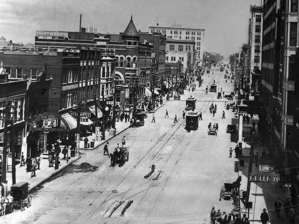
It's not a new idea. As you can see from the photo, Broadway used to have a trolley running north and south. Re-establishing it would allow for more intense development, more excitement and more activity along what once was the city's main business street.

The transfer station itself should be linear. The BNSF line obviously should remain elevated; but the structure on which it sits should be considered an asset instead of a barrier. A linear transfer station, stretching from the Santa Fe parking garage past the Santa Fe station, over the old I-40 site (the future boulevard) and down to the new convention center and urban park would allow commuters to disembark at any of several exits, and reduce congestion at a single exit far removed from most downtown venues. In other words, a passenger could choose to exit at the Santa Fe parking garage, at the Amtrak station/Cox Center/Thunder arena, at Bricktown, the new convention center or the urban park, minimizing his or her walk from the train. That's a lot better than being dropped off at, say, the Rock Island yard and having to figure out how to get several blocks to his or her desired destination. At the same time, the number of people exiting at any single site is reduced.
Because the transfer station operates on two levels, passengers would be able to take an escalator from the train level to the street level. The elevated structure would be gutted (I assume it's filled with fill dirt) and turned into a functional building, sheltered from high-volume vehicular traffic of E.K. Gaylord, but providing access to all the cross streets along the way. Only the west wall with the iconic mural would remain the same.
Amtrak and commuter rail would also include express lines that would only stop at the downtown Amtrak station. Thus, traffic from Edmond to Norman would not take the Broadway route, but would remain on the BNSF right-of-way. As a result, their journeys would not be delayed by a detour through Automobile Alley.
Under this approach, the cost of a transfer station would be significantly reduced, perhaps by a third or one-half. That would allow for more MAPS3 tax dollars to be committed to the downtown circulator system, extending it.
There is another problem, however, that Anton Classen didn't face. The Federal Railroad Administration, which now regulates BNSF et al., prohibits light rail vehicles from operating on the same tracks at the same time as FRA-compliant heavy rail cars, such as locomotives and freight equipment. Besides the obvious safety factor, there's a rumor that Detriot persuaded federal authorities to include that regulation to heighten its advantage over rail during the transition from passenger rail to cars. One notable exception is the New Jersey Transit line from Camden to Trenton, which received an exemption on the condition that light rail operates only during daytime hours and Conrail freight service only at night, with several hours separating the two. That arrangement wouldn't be practical in central Oklahoma. But it highlights the fact that streetcars won't be rumbling up to Edmond or down to Norman using the rail right-of-way, unless it has its own dedicated track; they'll be confined to streets. The commuter rail can come down Broadway, but would probably overwhelm the smaller downtown streets. A hybrid approach is therefore the best solution.
THE AIRPORT
A passenger rail system would be short-sighted if it did not include a connection to Will Rogers World Airport.
That's why it was so critical to preserve the Union Station rail yard, to allow a connection between it and the Santa Fe line in the designs of the I-40 realignment.
I live in Edmond. It's almost as easy for me to use the Tulsa airport as the Will Rogers airport when I'm flying out of state. We won't even talk about the annoying security screening - just getting to and from the airport, hauling my luggage, getting on and off a GiddyUp, and paying for the parking privilege is irritating.
It would be much simpler for me to board a train in Edmond, transfer to the airport line at the downtown Oklahoma City linear transfer station, and travel west past the Union Station and along Highway 152 (the Newcastle Road), then south at Meridian along a new line that drops me off inside the Will Rogers terminal itself. St. Louis, San Francisco and other cities do this with considerable success.
Most people don't take into consideration the cost of building parking spaces. Think of the parking garage at the airport. Each parking space might literally cost $30,000 to build. The surface lots take up endless acres of valuable real estate. It simply makes more sense to connect the entire metro area to the airport by adding about two miles of rail line (from Meridian and Airport Road) and installing the trains and stations.
CORE TO SHORE
Finally, thought should be given to making the downtown urban park and surrounding redevelopment almost vehicle free.
As the circulator system is developed, it should be planned with a southern extension in mind that would serve the area south of Reno. A federal office building employee, for example, should be able to board the light rail vehicle and easily travel to the urban park, the new convention center, or Wheeler Park housing. By the same token, a Wheeler Park condo resident should be able to take the circulator to his downtown job, a Redhawks game, or a festive evening in Bricktown without using his or her car. That resident might also be a student at OU or UCO, and should be able to access either campus without adding a vehicle to the roads.
I have a few more ideas about Core to Shore, but we'll save that for another blog posting.
Thinking ahead to where people will want to travel 20 or 30 or even 50 years from now is the key to designing passenger rail systems today.