
Now, after most major urban areas have re-established trolleys and rail systems, Oklahoma City has finally amassed the political momentum to jump on board. One of the selling points of the city's MAPS III initiative was overwhelming support for light rail in the urban core. That quickly translated to "only six miles" according to city planners, plus an ambiguous reference to a transfer station that would connect Amtrak passengers and future commuters to the fledgling light rail system. Couple that with the Obama administration's grand talk of a long-term investment in high-speed rail, and suddenly passenger rail is again a hot topic. Even the recalcitrant Oklahoma Department of Transportation - which owns, thanks to Jim Townsend, more rail than any other state in the union - put together a modest bid to scarf up President Obama's high-speed rail bucks.
Let's jump ahead a bit and see just what will be necessary to make passenger rail a reality in central Oklahoma.
FIRST, A LITTLE HISTORY
Unlike most eastern cities, rail existed before the city itself. Look at an early-day rail map of Oklahoma, and it's evident the state was crisscrossed with some 1,500 miles of rail lines at an early age, even predating statehood. They made the oil boom of the 1910s and 1920s possible, bringing heavy equipment into muddy fields where dirt roads were wholly inadequate.
By 1870 a total of 52,900 miles of railroads existed in the United States, with 1,350 miles in Missouri and 660 in Kansas, but none in Indian Territory. Kansas wanted an outlet to the Gulf of Mexico; plans for a transcontinental railroad from St. Louis to the Pacific were being made at the same time. In the Reconstruction-era treaties between the United States and the several Indian nations after the Civil War, a stipulation was added that one north-south and one east-west railroad were to be allowed through Indian land. Only then did the Missouri, Kansas and Texas Railway Company (MK&T, or Katy, originally known as Union Pacific, Southern Branch) start building its line from Kansas toward Denison, Texas.
Two nominally independent companies, the Southern Kansas (of Kansas, 1885) and the Gulf, Colorado and Santa Fe (1873), both controlled by the Atchison, Topeka and Santa Fe railroad, completed a north-south main line from Kansas to Purcell by 1887. The same Southern Kansas in 1886-87 also constructed a line from Kiowa, Kansas, through Woodward to Goodwin and on to Amarillo, Texas, gaving the Santa Fe a shortcut to its western lines.
The Chicago, Rock Island and Pacific crept slowly south from Kansas toward El Reno, especially after the opening of the Unassigned Lands in 1889, and reached the Red River in 1892. Most of these lines followed old, established trade routes or cattle trails such as the Texas Road and the Chisholm Trail. After a pause in construction due to the panic of 1893, expansion resumed, with many competing lines even running parallel to each other. Oklahoma City was built literally at a crossroads of rail beds, with eight major lines spreading out like a spider's web from the core of the city.
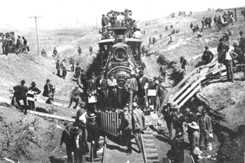
Thousands of settlers were brought into Oklahoma by rail for the seven land runs between 1889 and 1895. Oklahoma City's Santa Fe station figures prominently in early photographs; indeed, the city spread out from the Santa Fe station as lumber and other construction goods were imported through it.
By the 1950s, rail passenger traffic was being replaced by high-speed highways and even faster airlines. Unused rail beds were removed and recycled, and rights-of-way abandoned. By 1965 the Oklahoma mileage had shrunk to 5,570. In 1995 Oklahoma railroad mileage was down to 3,434, or about half of what it had been in 1920. Most of central Oklahoma's rail beds have not been upgraded in years. Only the BNSF carries regular heavy traffic, and shares part of that roadway with Amtrak's limited service on the Heartland Flyer.
This map from the Oklahoma Department of Commerce gives you an idea of how Oklahoma City is inherently connected to North American destinations by rail. Regrettably, freight is the only real beneficiary of that network today.

It would be virtually impossible to establish new rights-of-way for commuter rail. Some cities, like Seattle and San Francisco, have found it less expensive to build commuter rail underground than disturb the matrix of streets and buildings in their cities. Oklahoma City is fortunate in that rights-of-way predate most of the city's development, and it only makes sense to utilize those assets in re-establishing passenger rail.
DOUBLE TRACK
The trick to efficient use of rail lines is double tracking. The old Santa Fe line wasn't designed for modern needs. And, while there's enough right-of-way to double-track, most of it remains a single line. When a north-bound train is coming through, all south-bound traffic must wait on a siding, and vice versa. Any single tracking becomes a bottleneck, which decreases efficiency, increases costs and frustration, and drives down ridership.
So the first major step that needs to be taken will be to double-track the BNSF right-of-way all the way from at least Norman to Edmond, and eventually further as the metro expands. That's the only way to ensure smooth and quick rail movement through the metropolitan area. And that's going to cost millions of dollars and take years to construct. Without it, commuter rail won't be a practical alternative to Broadway Extension or I-35. And without commuter rail, the downtown circulator will be nothing more than a cute plaything for those who are already downtown - Devon Tower employees, the few daring souls who live and work downtown, or the occasional Thunder fan or Bricktown aficionado.
Commuter rail and the downtown circulator are critical to each other, like Siamese twins. To plan one without considering the requirements of the other is futile to the ultimate success of either system.
DOWNTOWN TRANSFER STATION
Current discussions call for a new transfer station somewhere in downtown Oklahoma City, at which commuters can get off their trains from Edmond and Norman (and Amtrak, for that matter) and board the light rail circulator system. That station would probably be built near today's Santa Fe station, or possibly the adjacent former Rock Island terminal. It would require literally thousands of future commuters to make that perfectly orchestrated transition in a matter of seconds.
In fact, three types of activity would occur in that station:
- Passengers accessing the downtown circulator system from suburbs and Amtrak;
- through traffic (such as Edmond to Norman or the airport); and
- passengers accessing Amtrak from suburbs and downtown.
All of that would be squeezed into a narrow corridor, with origins in the 1880s. What's more, during the 1930s the Santa Fe track was elevated, in a successful effort to separate rail from surface vehicular and pedestrian activity. On top of all that, BNSF still operates heavy freight traffic through the Mexico-to-Canada corridor.
Anyone who has used Denver's successful commuter rail system knows it operates without the use of a single transfer station. The trains transition from segregated rail lines to a street-level loop through downtown, where commuters can disembark at a multitude of stops. In addition, Denver's popular (and natural gas powered) free buses flow up and down the 15th Street pedestrian mall, giving travelers access to millions of square feet of office and retail space.
Here's an idea: Imagine a commuter train coming in from the north on the BNSF right-of-way. Have it exit west along N. W. 15th and 16th Street and then run straight down Broadway to around Third Street, making stops every block to drop off and pick up passengers. At the curve, have it rejoin the BNSF right-of-way and enter the new transfer station. With that approach, a significant number of passengers exit the train along Automobile Alley, thereby reducing the number of people being forced through the new transfer station. In addition, the train would serve the local needs of moving up and down Automobile Alley for over a mile, alleviating the need for a separate light-rail track along Broadway.
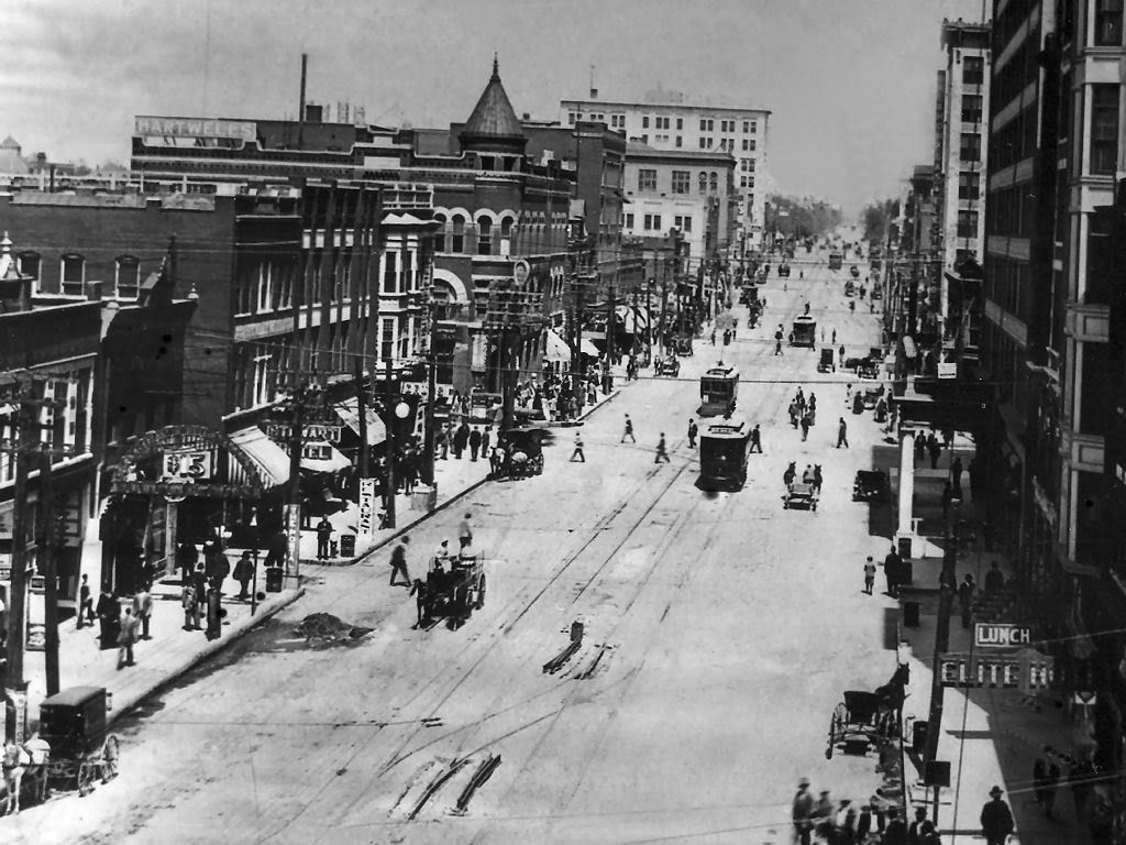
It's not a new idea. As you can see from the photo, Broadway used to have a trolley running north and south. Re-establishing it would allow for more intense development, more excitement and more activity along what once was the city's main business street.
The transfer station itself should be linear. The BNSF line obviously should remain elevated; but the structure on which it sits should be considered an asset instead of a barrier. A linear transfer station, stretching from the Santa Fe parking garage past the Santa Fe station, over the old I-40 site (the future boulevard) and down to the new convention center and urban park would allow commuters to disembark at any of several exits, and reduce congestion at a single exit far removed from most downtown venues. In other words, a passenger could choose to exit at the Santa Fe parking garage, at the Amtrak station/Cox Center/Thunder arena, at Bricktown, the new convention center or the urban park, minimizing his or her walk from the train. That's a lot better than being dropped off at, say, the Rock Island yard and having to figure out how to get several blocks to his or her desired destination. At the same time, the number of people exiting at any single site is reduced.
Because the transfer station operates on two levels, passengers would be able to take an escalator from the train level to the street level. The elevated structure would be gutted (I assume it's filled with fill dirt) and turned into a functional building, sheltered from high-volume vehicular traffic of E.K. Gaylord, but providing access to all the cross streets along the way. Only the west wall with the iconic mural would remain the same.
Amtrak and commuter rail would also include express lines that would only stop at the downtown Amtrak station. Thus, traffic from Edmond to Norman would not take the Broadway route, but would remain on the BNSF right-of-way. As a result, their journeys would not be delayed by a detour through Automobile Alley.
Under this approach, the cost of a transfer station would be significantly reduced, perhaps by a third or one-half. That would allow for more MAPS3 tax dollars to be committed to the downtown circulator system, extending it.
There is another problem, however, that Anton Classen didn't face. The Federal Railroad Administration, which now regulates BNSF et al., prohibits light rail vehicles from operating on the same tracks at the same time as FRA-compliant heavy rail cars, such as locomotives and freight equipment. Besides the obvious safety factor, there's a rumor that Detriot persuaded federal authorities to include that regulation to heighten its advantage over rail during the transition from passenger rail to cars. One notable exception is the New Jersey Transit line from Camden to Trenton, which received an exemption on the condition that light rail operates only during daytime hours and Conrail freight service only at night, with several hours separating the two. That arrangement wouldn't be practical in central Oklahoma. But it highlights the fact that streetcars won't be rumbling up to Edmond or down to Norman using the rail right-of-way, unless it has its own dedicated track; they'll be confined to streets. The commuter rail can come down Broadway, but would probably overwhelm the smaller downtown streets. A hybrid approach is therefore the best solution.
THE AIRPORT
A passenger rail system would be short-sighted if it did not include a connection to Will Rogers World Airport.
That's why it was so critical to preserve the Union Station rail yard, to allow a connection between it and the Santa Fe line in the designs of the I-40 realignment.
I live in Edmond. It's almost as easy for me to use the Tulsa airport as the Will Rogers airport when I'm flying out of state. We won't even talk about the annoying security screening - just getting to and from the airport, hauling my luggage, getting on and off a GiddyUp, and paying for the parking privilege is irritating.
It would be much simpler for me to board a train in Edmond, transfer to the airport line at the downtown Oklahoma City linear transfer station, and travel west past the Union Station and along Highway 152 (the Newcastle Road), then south at Meridian along a new line that drops me off inside the Will Rogers terminal itself. St. Louis, San Francisco and other cities do this with considerable success.
Most people don't take into consideration the cost of building parking spaces. Think of the parking garage at the airport. Each parking space might literally cost $30,000 to build. The surface lots take up endless acres of valuable real estate. It simply makes more sense to connect the entire metro area to the airport by adding about two miles of rail line (from Meridian and Airport Road) and installing the trains and stations.
CORE TO SHORE
Finally, thought should be given to making the downtown urban park and surrounding redevelopment almost vehicle free.
As the circulator system is developed, it should be planned with a southern extension in mind that would serve the area south of Reno. A federal office building employee, for example, should be able to board the light rail vehicle and easily travel to the urban park, the new convention center, or Wheeler Park housing. By the same token, a Wheeler Park condo resident should be able to take the circulator to his downtown job, a Redhawks game, or a festive evening in Bricktown without using his or her car. That resident might also be a student at OU or UCO, and should be able to access either campus without adding a vehicle to the roads.
I have a few more ideas about Core to Shore, but we'll save that for another blog posting.
Thinking ahead to where people will want to travel 20 or 30 or even 50 years from now is the key to designing passenger rail systems today.


1 comment:
ACOG has made public their most recent proposals on the proposed intermodal hub for downtown Oklahoma City. They can be seen at http://www.acogok.org/.
I applaud the idea of using the Site B location adjacent to the current Amtrak station. It is much better than the Rock Island yard (Site A) or the lumber yard (Site C) options.
My main concern about the proposal is the use of the streetcars on E.K. Gaylord Blvd., which should be dedicated to higher-volume vehicular traffic. Their design places a streetcar station at that location. That would increase the congestion in those couple of blocks, and raise the hazard of pedestrians crossing a critical north-south vehicular corridor.
The elevated section of track was constructed during the 1930s to allow vehicular traffic across the Santa Fe tracks, which often were blocked by long trains at the siding. The elevation is filled with dirt. My suggestion is to reconstruct the elevated track by excavating the dirt fill and placing either (a) the streetcar transfer and/or (b) pedestrian access underneath the tracks. This would provide an enclosed transfer connection from streetcar to commuter vehicle - always a plus - while removing that from the congestion of E.K. Gaylord. Escalators could move pedestrians from the ground level to the track level station. Doors to the east would open directly onto the promenade entrance to Bricktown. To the west would be a direct connection to the street level of the Amtrak station.
I don't know what attention has been given to this idea, but in effect urban planners from the 1930s set aside a 120'-wide swath of downtown from development. That became two blocks long in the 1960s urban renewal, since the construction of the Myriad Convention Center blocked through-traffic on Main. That was made permanent by the MAPS canal construction in Bricktown.
We now have an opportunity to convert a two-block long wall overlooking Bricktown into a vista that creates a remarkable introduction to Bricktown to any passengers coming into the city by rail. With a depth of 120', with a future expansion to 160', there is plenty of room to do a lot of pedestrian and streetcar traffic without conflicting with either the higher-speed rail overhead or the vehicular traffic on Gaylord.
Post a Comment